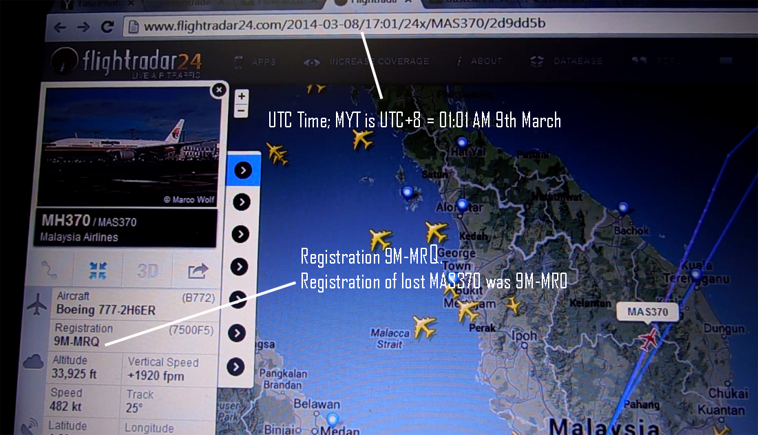
This is the Playback of the Malayasian Boeing 777 MH370 aka MAS370 with Flight Registration 9M-MRQ which is believed to be a twin/clone of the lost MH370 with Flight Registration No. 9M-MRO. As per one of the conspiracy theories: QUOTE: “We can not trust the information Malaysia has released due to the delays and constant recants and changes,” Stonier asserts, adding to note flight MH370 9M-MRQ has climbed to 49,000 feet at latitude 6.7 longitude 103.76 and is now in the red – same spot where the first MH370 vanished." UNQUOTE [Ref; Above link]
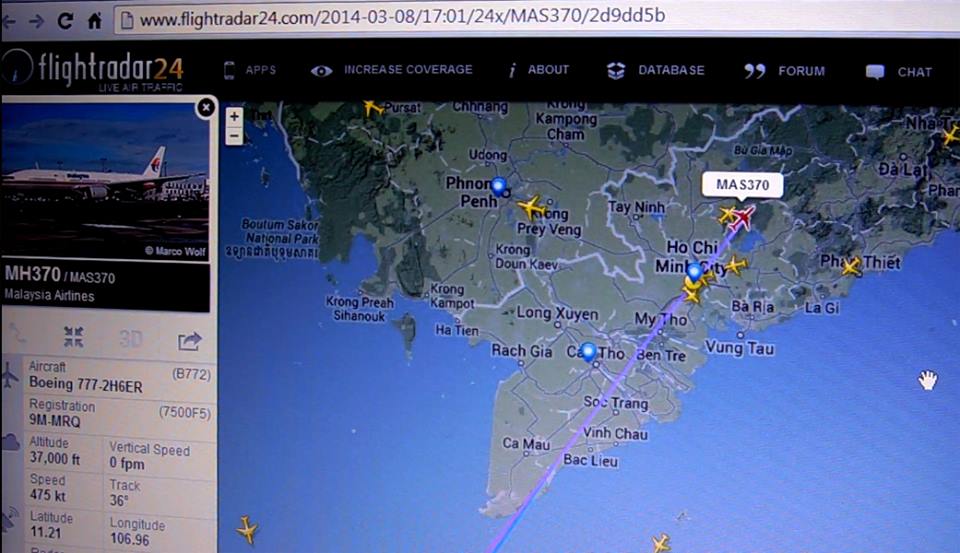
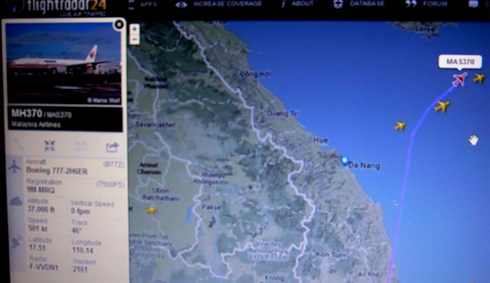
Immediately after the news of the disappearance of MH370 [9M-MRO Screenshot below when it disappeared], I thought of finding more information on ADS-B radar data from the lost 9M-MRO and searched for ADS-B radar data possibly archived on the Internet for the lost flight as there are a few websites that display live ADS-B radar data in almost near realtime notably http://www.flightradar24.com, I ended up at an URL archiving a playback of the Flightradar24 server recording for another Malaysian MH370 flight which apparantly took a flight to Beijing just one day after the other MH370 disappeared on March 8, 2014 [ See the playback here]. Though this was not the lost flight [Lost flight playback at: http://www.flightradar24.com/2014-03-07/16:46/12x/MAS370/2d81a27 ], critical observations now giving rise to certain queries which are already appearing in various media. A playback of the second MH370 Registration no. 9M-MRQ is at https://www.youtube.com/watch?v=9bL68rBUggg . Screen shots of Flightradar24 playback for certain observations made me believe that conspiracy theories cannot be ignored right away. These need to be analyzed and investigated.
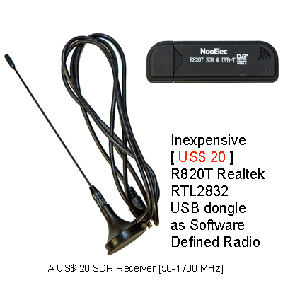
The decoded automated digital transmission from an ADS-B transmitter fitted on an aircraft transmits different important parameters about a flight like ALTITUDE, SPEED, VERTICAL SPEED [+/-], DIRECTION OF the FLIGHT [also called HEADING or 'COURSE'], LOCATION of the the flight in LATITUDE and LONGITUDE, the Flight's COUNTRY OF ORIGIN, TYPE of Aircraft [e.g. 777], ICAO No., REGISTRATION No., AIRCRAFT's CALL-SIGN [This is the "IDENTIFICATION"],and Squawk CODE of the Aircraft etc. All these parameters are digitally encoded which can be decoded only using approriate radio receiver with compatible technology/computer software. ADS-B [Automatic Dependent Surveillance Broadcast] is the latest robust technology introduced for real-time automated tracking of aircrafts. ADS-B is a digital broadcast from an aircaft without any human intervention taking place twice every second, but the success of the system in real-time tracking of aircrafts depends on public participation [i.e. why the word "dependent"; also the encoded datas about the location of the aircraft/speed/altitude/course/vertical speed etc. are "dependent" on the reception of the signals from GPS Navigation Satellites], i.e. feeding of the ADS-B data to tracking servers through TCP/IP. The lost Malaysian MH370 was tracked by 3 volunteer stations in Malaysia as disclosed by Flightradar24. Most of the ADS-B data coverage is due to the "Voluntary" effort of the civilians who feed datas to the ADS-B servers. This can be done by using a compatible equipment/devices/radio receiver [usually an Analogue to Digital converter (ADC) like this cheap USB Dongle]. Members of the public can legally receive the ADS-B digital transmissions from the aircrafts on 1090 MHz [1.090 GHz]. This frequency has a good penetrability through concrete structures. I have found that with just a 12 cm long vertical antenna kept indoor, it is possible to receive aircrafts flying nearby. Here are some screenshots while tryling to track aircrafts flying near to my house. As I am located very near to the airport, even with a small indoor antenna the aircrafts could be tracked in real-time. Flightradar24's coverage is primarily made up of data contributed by volunteers from around the world. 4,000+ aviation enthusiasts with ADS-B receivers regularly feed data to Flightradar24 network. Anybody can help increasing the coverage in their area by contributing to ADS-B data feeding. See details at: http://www.flightradar24.com/increase-coverage/
|

The Beast -- A STAND ALONE ADS-B receiver
[ Cost: 800 Euro ]
ADSBScope Screenshot:
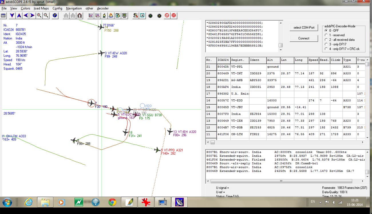 ADSBScope Screenshot
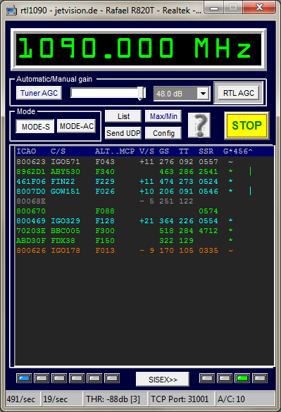
RTL1090 [ 1090 MHz ] Software to decode ADS-B transmission
Here are some analysis of ADS-B data of the lost MH370 by aviation enthusiasts at http://www.reddit.com/r/MH370/comments/28otnj/adsb_data/ Here, by overlapping the datas archived by Flightradar24 and Flightaware certain observations were made which is pointing to an apparant contradiction in certain parameters received by the ground stations.
To understand how the joint technical team of search operation has been trying to zero in on the possible area where MH370 might probably crashed, Here is a detailed report on the MH370 search by Australian Transport Safety Bureau: http://www.jacc.gov.au/media/releases/2014/june/mr052_MH370_Definition_of_Sea_Floor_Wide_Area_Search.pdf This is an informative mustread article on Boeing 777 explaining various technologies used by the aircraft to navigate [including ACARS SATCOM (Satellite Communication) and how it works and the methodologies employed for the search.
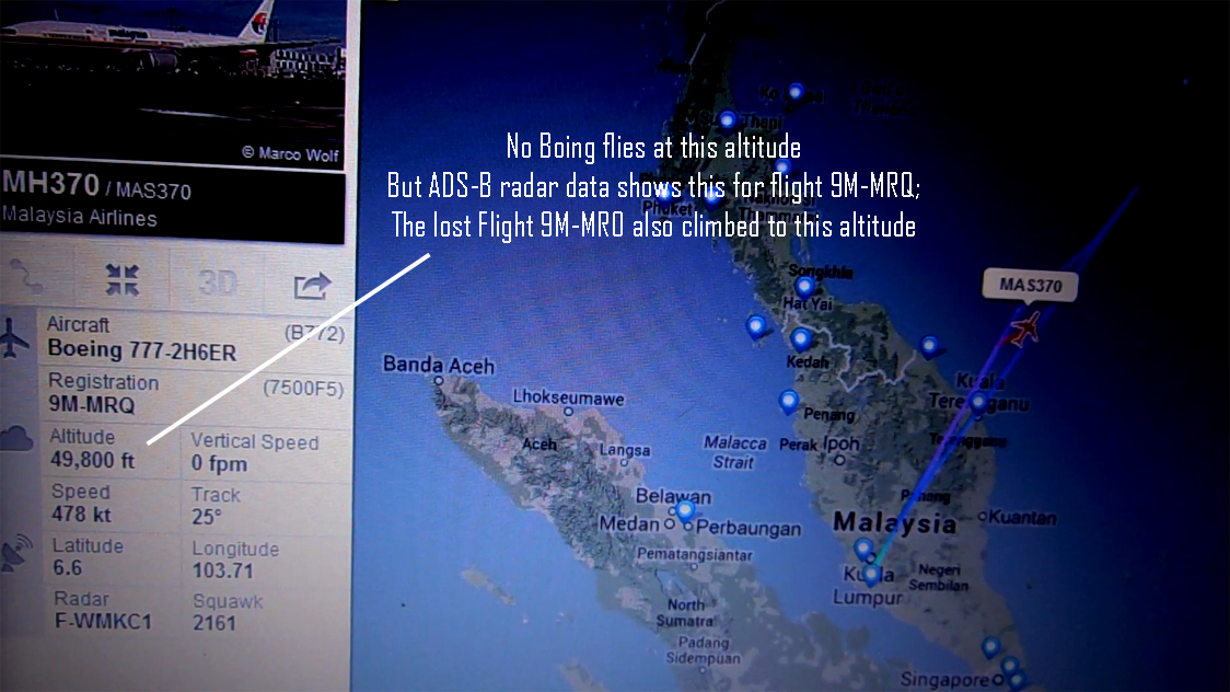
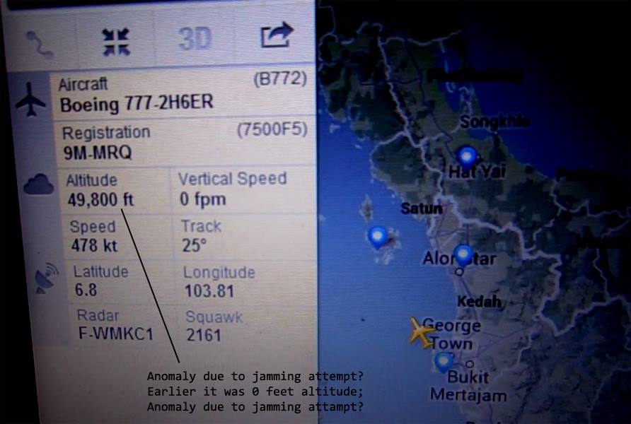
At least four ADSB radars are seen receiving its ADS-B beacon. QUOTing from: http://beforeitsnews.com/events/2014/03/malaysia-airlines-370-had-secret-twin-radar-data-shows-2432870.html: "Stiller presents evidence that the second plane is involved with the mystery, and the second plane was not on any other scheduled routes that night. Not only that, Stiller says he thinks public radar data from MH370 was pulled from the Internet shortly after the crisis began..."My screen shots come from the data within 48 hours of the start of this," he told Deborah Dupré in an email. "Remember 9M-MRO is the 'missing plane.'"....radar data from FlightRadar24 showing flight MH370 disappearing at latitude 6.97 longitude 103.63 — "the flight ends, gone, altitude 0 feet. That's all the radar shows for this flight. This is 9M-MRO," " he further says that the radar data for 9M-MRQ from FlightRadar24 also operating as MH370 / MAS370 matches more closely all the reports Malaysia made regarding altitude changes and steep climbs to 49,000 feet. "We can not trust the information Malaysia has released due to the delays and constant recants and changes," Stonier asserts, adding to note flight MH370 9M-MRQ has climbed to 49,000 feet at latitude 6.7 longitude 103.76 and is now in the red -- same spot where the first MH370 vanished."
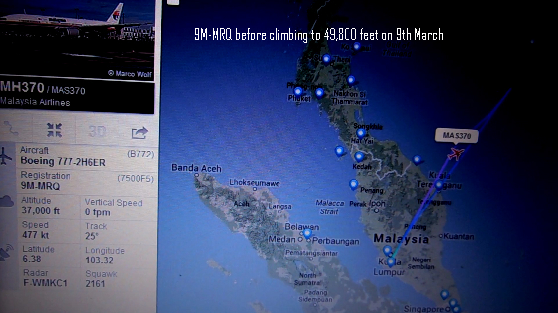
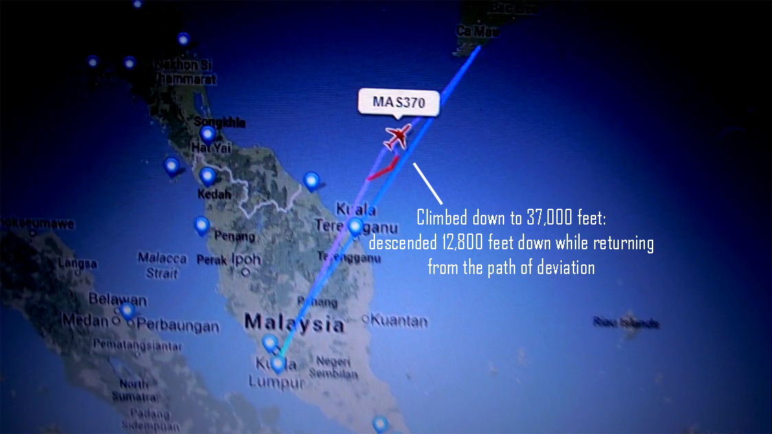
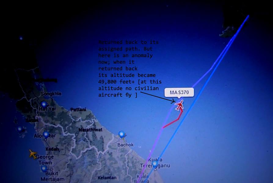
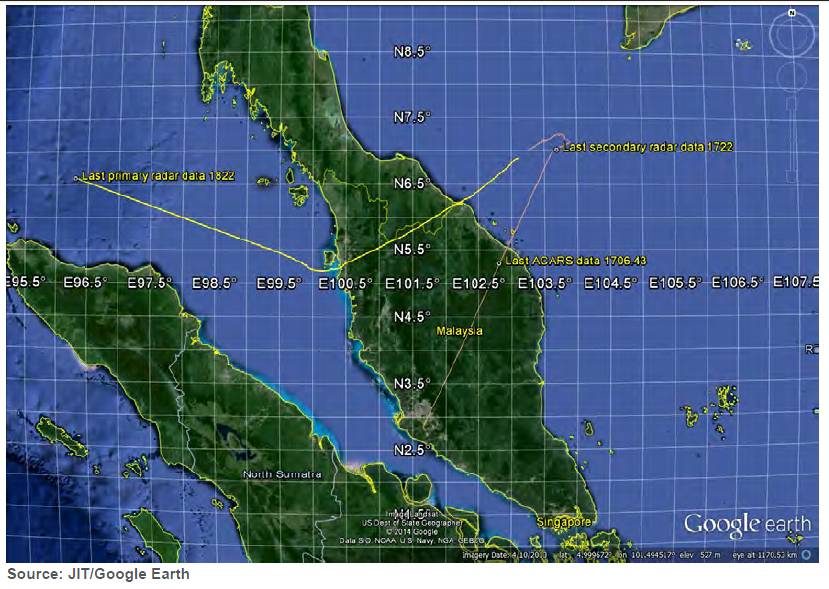
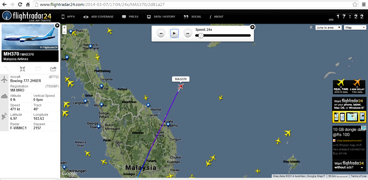
How both the aeroplanes showing almost identical ADS-B radar data?, i.e. 9M-MRQ climbing to 49,800 feet almost at the same spot [where MH370 with registration 9M-MRO disappeared on 8th March, 2014] and then at no time the the ADS-B decoded data showed climbing to a normal altitude [descended 12,800 feet while the flight took the normal course after the apparant deviation? On March 16, 2014 [Sunday], Malaysian authorities said that 9M-MRO's ACARS system was disabled before that final radio transmission at 01:19 MYT when the pilot made the last VHF radio contact [on 120.9 MHz] with the Air Traffic Control and signing off with the words "Good night Malaysian three seven zero". But later the last Secondary Radar [ACARS- Aircraft Communications Addressing and Reporting System] transponder contact was said to be at 17:21 UTC [ 01:21 AM MYT ] and the location reported was 06°55'15"N Latitude 103°34'43"E Longitude [ In Decimal: Latitude 6.920833333333333N Longitude 103.5786111111111E Click here for Conversion to Decimal degrees]. My playback at at 24X speed for the lost MH370 [Registration 9M-MRO] from the URL http://www.flightradar24.com/2014-03-07/17:04/24x/MAS370/2d81a27 shows altitude 0 at Lat/Long 6.97N, 103.67N. The decimal degrees noted almost identical at 49,800 feet i.e. Latitude 6.6N Longtitude 103.71E, i.e. prior to the disappearance of the 9M-MRO the previous day almost at the same spot/area. As per Flightradar24 the last ADS-B data from the aircraft was collected at 17:21:03 UTC [ 01:21:03 MYT ], contrary to official version that the aircraft took a 270 deg to west, In fact it was seen turning 40 degrees slightly to the right. This was between 17:19 UTC and 17:20 UTC the aircraft changed heading from 25 to 40 degrees.
ACARS can also be received by amateurs/hobbyists using ACRSD and PlanePlotter. Here is a tutorial on how to receive ACARS using a low cost RTL2832 USB dongle: http://www.rtl-sdr.com/rtl-sdr-radio-scanner-tutorial-receiving-airplane-data-with-acars/
There are servers around the world who feed live ACARS data to Internet. To view live: http://www.acarsd.org/fleetlist.html ,enter the flight Registration No. or flight number. For example, to search 9M-MRQ, we can make a query by typing the following to the web browser: http://www.acarsd.org/flsearch.html?reg=9M-MRQThere are aviation enthusiasts who are keen to take photographs of aircrafts. A photograph of 9M-MRQ taken by a hobbyist is at:
http://www.planespotting.net/R_9M-MRQ.html Here is a "Confidential Report" published in Social Media website Facebook by Malaysian politician/Defence Minister Hishammuddin
Hussein: https://www.facebook.com/media/set/?set=a.10152221402889355.1073741995.72613804354
According to Australian Transport Safety Bureau information, the last ACARS transmission received by Kuala Lumpur Air Traffic Control was at: 17:06:43 UTC. It mentions another Secondary Radar received at 17:22 UTC. This might be the reference to the ADS-B Secondary Radar transmission.
As per Boeing pilot Aroosh Naqvi from Pakistan: "Based on my own professional experience, I have little doubt that the actions that led to the disappearance of MH370 were deliberate, pre-planned and executed by trained persons in the cockpit. However, the question remains as to whether the captain and first officer of MH370 acted on their own accord or under pressure. Going to such lengths to make the aircraft disappear off radar, and yet, fail to mask ACARS transmissions is an error that a skilled pilot is unlikely to make.
However, ACARS transmissions may be easily overlooked by someone with less insight into the aircraft systems, under whose orders the crew might have been acting. Turning off the ACARS system is not as simple as the one switch that turns the transponder on and off. ACARS is a system buried within the aircraft’s computer architecture and is usually operated automatically. It can only be shut off by removing power to the entire system by pulling circuit breakers – otherwise, obviously not used inflight"[ http://blogs.tribune.com.pk/story/21502/a-pilots-perspective-on-the-disappearance-of-mh370/]
Now, as reported [ http://www.nytimes.com/2014/03/15/world/asia/malaysia-military-radar.html?_r=1 ]the lost MH370/MAS370 with registration 9M-MRO was ascending to 45,000 feet and then dropping precipitously into the 20,000 foot range before disappearing. This information is based on Secondary Radar data of Malaysian Military . As per official technical specifications, a Boeing is capable of cruising at an altitudes up to 43,100 feet. This does not mean the pilots would take it to extreme limits. Then why both the Boeings were cruising between 45,000 feet to 49,800 feet at the same location on two different dates?
The ADS-B radar screenshot of the lost MH370 aka MAS370 Registration 9M-MRO from flightradar24:
ADS-B and Secondary Radar are two different technologies. ADS-B is the most modern technology which works without human intervention. In the EU airspace planes with a weight above 5,700 kilograms or a max cruise of over 250 knots will be required to carry ADS-B from 2017 [new planes from 2015]
Civilian Boeing 777s don't fly at more than 40,000 feet altitude under normal circumstances. Why then both [MH370/MAS370 with registration 9M-MRO (lost on 8th March) & MH370/MAS370 with registration 9M-MRQ (seen on ADS-B radar the very next day? But UTC time stamp 8th March 17:00 hrs which would be around 1:01 AM Malaysia time)] the aircrafts were cruising above 43,100 feet?] If it is an anomaly due to some malfunctioning of the ADS-B equipment failing to get a GPS fix [ http://en.wikipedia.org/wiki/Time_to_first_fix ]from the navigation satellites, how can it happen twice (even if a coincidence) at the same place in two aircraft? This is to be noted that the report of 9M-MRO climbing to 45,000 feet was based on Military Secondary Radar information.
The report of 9M-MRO climbing to 45,000 ft and its uneven descent was based on Secondary Radar of Malaysia Military [Secondary Radar data are either retrieved by sending a VHF radio signal [131.550 MHz is the International Primary ACARS frequency in the VHF Band. Here is a list of frequencies for different countries/areas] to the aircraft's ACARS transponder, or it's availablity is based on decoded information displayed on the secondary radar screen at periodic intervels. The ACARS don't transmit at very frequent intervel. Only, if an aviation company subscribes to Rolls Royce, ACARS datas are mandatorily monitored by Rolls Royce (manufacturer of Boing 777 engine) at it UK HQ. In this case datas related to the health of the aicraft are collected every half an hour through the INMARSAT satellite system. Malaysian Airlines did not have a subscription for this service and the pings received by INMARSAT did not contain any information]. ACARS data may not be available to the ground radar stations during long distance trans-oceanic flights of aircrafts as the VHF have only Line-of-Sight coverage of upto about 300 km [Here is how a sample ACARS (Aircraft Communication Addressing and Reporting System) data packet sounds. It was recorded by Jeremy Cooper from the secondary North American ACARS frequency of 130.025 MHz. Recorded in Petaluma, California on 2006-8-15]. In long distance trans-oceanic flights, pilots may keep in touch with the ground station/s through High Frequency (HF) Radio. But HF Radio is not reliable all the time as HF radio signals propagates through "Ionosphere" and propagation through Ionosphere varies depending on variuos factors. Aircrafts can transmit ACARS in HF also. Here is a list of HF ACARS frequency. During long distance trans-oceanic flights pilots can use Satellite phone during emergencies. In case of Primary Radar, the aircraft does not transmit any radio signal back to the radar station; The displayed information (aircraft appears just like a 'dot' in the radar screen) is based on radar signal bounced off from the aircraft. Whereas a Secondary Radar can transmit a radio signal to the transponder onboard an aircraft; in response to this signal, the aircraft transponder [Transmitter Responder] automatically transmits back an endoded radio signal with different information about the aircraft. Secondary surveillance radar [SSR] is a radar system used in air traffic control [ATC], that not only detects and measures the position of aircraft i.e. range and bearing, but also requests additional information from the aircraft itself such as its identity and altitude. Unlike primary radar systems that measure only the range and bearing of targets by detecting reflected radio signals, SSR relies on targets equipped with a radar transponder, that replies to each interrogation signal by transmitting a response containing encoded data. SSR is based on the military identification friend or foe [IFF] technology originally developed during World War II, therefore the two systems are still compatible. Monopulse secondary surveillance radar [MSSR], Mode S, TCAS and ADS-B are similar modern methods of secondary surveillance.
Whether primary [primary radar gives only approximate location] or secondary, radar coverage fades as the aircraft flies away. Beyond 240 km, primary and secondary radar are not reliable and air crew keep in touch with air traffic control using high-frequency radio [as those used by ham radio hobbysists] for long distance communication using the "Ionosphere" to reflect back the radio signals over vast strethces. ADS-B technology faces the same problem; without adequate number of receiving and feeding stations, the aircraft may be out of tracking coverage.
When a catastrophic incident happened to the Malaysian Boeing 777 [ MH370 aka MAS370 Registration 9M-MRO], it is logical to believe that the national aviation authority of Malaysia to critically examine their similar MH370 aircrafts [if they have really one] and probably to ground their next flight/s.Was there really a MH370 flight on 9th March too from Kualampur to Beijing while the whole world was stunned at the mysterious disappearance?
Is there some jamming attempt [twice] by unkown classified secret satellite or military aircraft intentionally jamming the ADS-B transmitters of both the aircraft at that particular location or hacked/jammed the ADS-B transmitter system of both the aircraft and transmitted a modified ADS-B signal [disguising MH370 to misguide] from another secret system (which may be a satellite or a classified military stealth aircraft doing the dirty job)? A programmable device can be reprogrammed or cloned to mimic another device to transmit a false report or sending a signal disguising as someone else or sending a position to be somewhere [and not the exact position] to misguide. Here is a video to demonstrate how a simulated position information can be transmitted from a hand-held VHF radio: http://youtu.be/0K-4FWybfe0 This demonstrates [audio piping using Sound modem by UZ7HO] how a ham radio Automatic Packet Reporting System [APRS-Registered Trademark of Bob Bruninga, WB4APR, US Naval Academy] digital transmission can be decoded using a RTL SDR dongle for plotting of mobile stations. The location information is based on the longitude/latitude programmed in to a Yaesu VX-8DR hand-held VHF two-way radio which is APRS(R) ready.