Live RF data on an interactive
Internet map

[ Wait for the Java Security Certificate window to appear. Click 'Yes'/'Run' and then Scroll down the page where the maps are! ]

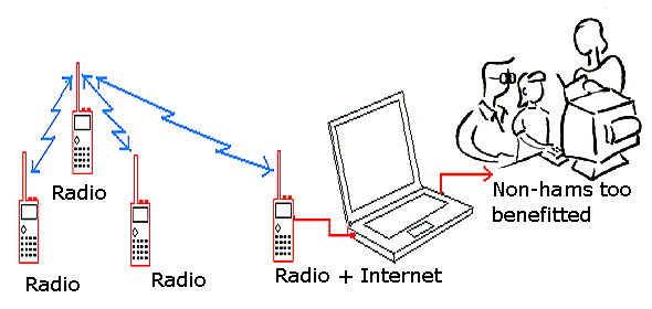
[Live RF Feed via VU2MUE on 144.800 MHz]

This page demonstrates ham radio capability in penetrating the Internet to serve useful purposes. This is a live APRS data feed page. APRS® stands for Automatic Position Reporting System. But this is not to be mistaken just as a mere automatic vehicle tracking system. It is real-time two way digital radio communication where many of the vital information are exchanged almost automatically. Non-hams can monitor ham radio APRS digital communication using this type of Internet web page.

To just get a feel of how APRS activity is going on at other parts of the world here are a few links:

| AE5PL | | WA4DSY | | SV1CNS  | | HB9PVI |

Radio & Beyond!

On the New Delhi map displayed below, we can see hams doing APRS® communication [If they wish they may talk or otherwise exchange APRS digital data using their radios]. If they transmit APRS digital data on 144.800 MHz [which is VU2MUE APRS frequency], a radio hooked to the Internet can pick up the radio signal and in-turn feed the data to the Internet. During this demo, in a simulated exercise, the mobile station VU2MUE-9 [In most probability this may be during a demonstration only. So if you don't see VU2MUE-9 on the map please feel free to contact him!] appears on the map from RF originated data. There may be position reporting from Non-RF originated stations also. The station WB4TLP appearing with a WX icon is a ham weather station feeding weather data to Internet and these data are also available on the Internet map for utility.

How to use the map?

[1]
Wait for the map to fully load [121 kb]

[2] If a message like 'allow the Signed Java Applet to run' appears. Do that by clicking 'YES' or 'RUN'.

[3] Click on the map to activate the JAVA controls [only for IE7].

[4] Initially VU2MUE would not appear. This means that the automatic position beacon from VU2MUE is not yet sent. Have patience till the beacon is sent. There are different beacon rates used by different stations depending on speed and necessity. The icon may also not come on the map if VU2MUE does not position report.

[5] When VU2MUE-9 [This is SSID of VU2MUE] appears on the map, 'CLICK' it. A small text line below the map tells the position information of the mobile station. It not only tells the position information but also tells other information like Speed of the vehicle, direction of travel [course], AMSL [Altitude, i.e. Above Mean Sea Level] etc. If a text message is sent, the message can also be read.

[6] To read messages. Press the 'M' key. Pressing M key writes the messages to the 'Java Console'.

Where to find the Java console?

The JAVA CONSOLE can be opened from Internet Explorer Browser's TOOLS > SUN JAVA CONSOLE

Problem opening the map?

If your browser is not JAVA enabled, the map would not load. Download JAVA 2.0 Runtime environment. If you get an 'Error opening Data' message in the browser status bar, it may be due to a LAN proxy connection where the appropriate ports are not open.


Peter Loveall (AE5PL) during a repeater installation. Peter Loveall took over the javAPRS support from Steve Dimse, K4HD.

VU2MUE trying the International Space Station at VU2NCT

|VU2MUE DXpedition Dream Page|


VU2MUE [previously VU2MSY] New Delhi APRS® Demo page

|How to get a ham radio licence?|
NEW Use of DTMF for Echolink operation

Download New Delhi APRS maps
| Download APRS map of India for UI-VIEW
|Boat on APRS.FI Google Map| -- Courtesy APRS.FI
Java Runtime Environment is necessary to run APRS maps [ Download ]
 __________________________________________________________
Special Call AT0D granted by WPC for
temporary operation from Guwahati [ DXPEDITION pending ]
Spot Frequencies: 7050 kHz, 14280 kHz and 21250 kHz
AT0D activated from Guwahati on March 21,2008
'In Wilderness' from Assam-Arunachal Pradesh Border: video-1 video-2
| Dehradun APRS demo | | APRS & other Demo Videos-1 2 3 4 5 6 7 8 9 10 11 12
| APRS demo at Disaster Management Exhibition |
__________________________________________________________


|What is APRS? |APRS benefits|  |Why javAPRS?|  |Map use instructions|
|Map Commands| |hams get UI-VIEW!| |APRS Presentations & Lectures|
|APRS Resource Collection| |VU2MUE DXpedition Dream Page|

| Boat Inspiration Video 6 MB |
| Metaphorical Inspiration: ME ON THE BOAT! |
| River Devil Acclimatization |
| Video Archive [Streaming Video]|
| Download 'A Guide to Ham Radio'|

NEW| Opentracker+V1.5 SMT with 1-Wire® Dallas DS1820|
_____________________________________
APRS
®
is the Registered Trademark of
Bob Bruninga WB4APR US Naval Academy

javAPRS 2.7b24 © 2006 Pete Loveall AE5PL
_______________________________________________


Why javAPRS?

Peter Loveall's [AE5PL] javAPRS [javAPRS 2.7b24 © 2006 Pete Loveall AE5PL] enables demonstration of ham to non-ham communication [Non-hams can only monitor APRS ham activities using their Internet Browsers]. It's utility during an emergency situation is self-explanatory.


Dr. Steve Dimse, K4HG

First APRS interface to the Internet

Dr. Steve Dimse (K4HG) first introduced the APRS interface to the Internet in 1999. This enabled the display of APRS maps on Internet Browsers and thus RF originated APRS information from mobile ham stations became accessible to the non-hams too. By profession Dr. Dimse was an emergency medical practitioner, who, according to himself 'hung-up' the stethoscope for his new passions.

During the demo, VU2MUE [SSID VU2MUE-9 Secondary Station IDentification for land mobiles]  feeds the real-time RF [Radio Frequency] data via a KENWOOD radio interfaced to a computer and that data reaches you via the Internet showing his positions & messages on a map. [a mobile station can in fact be tracked if the Internet map is monitored dedicatedly]. VU2MUE logs on to Rin Fukuda's (JG1VGX) Tier 2 T2JAPAN APRS server using Late Roger Barker's (G4IDE) UI-VIEW and then the data is internationally distributed from T2JAPAN tier 2 server. Mobile ham stations can remotely text message or send e-mail via the VU2NCT IGate even without a direct Internet connectivity. It is advised that 'live data feeding' should be done only through Tier 2 servers.

UI-VIEW by Roger Barker, G4IDE

Roger Barker's [G4IDE] UI-VIEW is a popular Windows based APRS application used by hams [radio amateurs licensed by the government] all over the world. UI-VIEW requires a validation from APRS server administrators. Being hams we always appreciate others also to become hams so that they can also use a beautiful software like UI-VIEW and enjoy the benefits of APRS Technology. There are many APRS applications now available for free.

After downloading UI-VIEW, hams in Asia region can contact Art Takashi, JA1OGS for APRS Server validation. Art Takashi, JA1OGS is the official Registrar of APRS for Region-3 Asian countries. He is the ham who introduced me to the world of APRS. Art Takashi's new Asia Region APRS registration page is: http://ja1ogs.com/reg.htm

Why this map?

The map below demonstrates the utility of an Interactive Internet map. This APRS map is accessible to hams as well non hams too. Text messages originated from RF stations can be monitored by non-hams. This has utility in ham radio emergency communication too [press 'M' and the read message at JAVA Console]

APRS benefits

  • Accurate position information about mobile & fixed stations.
  • Direction finding for precise beaming.
  • Tracking a mobile station [useful during emergency operation/tactical situation when prompt receipt of information about positions and progress of mobile stations is of utmost necessity for efficient coordination]
  • Line-of-Sight Distance and bearing of stations from base station available just at the click of a button.
  • Monitoring of 'radio to radio digital text messages' on an Internet browser. Non-ham family members of a ham can track him/her and read messages. During emergencies, if the Internet does not fail, this would help non-hams to monitor emergency messages.
  • Monitoring of real-time weather information originated from ham radio weather stations [Real-time Weather information like Wind Speed, Wind Direction, Temperature, Barometric Pressure, Humidity, Rainfall etc. are available on this map with just the click of a button.
  • Plotting of objects on the map. For example an accident site, crash site, intimation about a traffic jam for route planning, fire site, flood, cyclone, land-slide, road blockage or information about a ham radio event etc.
  • Allows important information to be exchanged without human intervention. This is important during a tactical or emergency situation, when we need to concentrate on other important jobs [for example 'Search & Rescue'].
  • Reduces voice traffic by avoiding repetitive conversations and thus economical use of the radio bandwidth. [e.g. What is your name/call-sign? [QRA/QRZ?]/Where are you? [ QTH? ]/Tell me your location so that I can turn my Yagi beam Antenna towards you/What is your e-mail?/Where are you going?/Are you busy?[ QRL?]/What is the height of your antenna/building?/How far you are from me?/In which direction you are now moving?/At what speed you are traveling?/what is the wind direction and wind speed?/What is the Temperature?/Is there any rainfall today?/What is the barometric pressure at your place......
     
    100% Radio & Beyond.....

    Stan Horzepa

    Stan Horzepa, WA1LOU

    APRS is 100% ham radio. javAPRS is 100% ham radio and beyond! It is '100% Ham Radio + Internet'. Who says it is not radio at all? Discard the 'Internet', APRS was there and would be. Advent of Internet eliminated the requirement of shared channel long distance Radio Frequency paths' and enhanced it by providing the high speed long distance backbones. Father of APRS Bob Bruninga [WB4APR] remarks in the foreword of ARRL book [APRS Moving Hams on Radio and the Internet - A Guide to the Automatic Position Reporting System] written by Stan Horzepa, WA1LOU: "The availability of almost infinite bandwidth for "free" on the Internet, fiber or backbones has made a paradigm shift that most ham operators have not awakened to yet..."

[ Read the instructions below the map to use various controls]

PLEASE HAVE PATIENCE
RIVERDEVIL DXPEDITION [ now pending ] New Delhi APRS MAP
[ Wait for the Java Security Certificate window to come > Click 'Yes' or 'Run'> Scroll down to use the map


Sorry, your browser doesn't do Java!


Clicking on a station shows its information
[distance and bearing from base station] in the status bar.

|VU2MUE Area Map |
 

javAPRS Commands (Case Insensitive) for the above map

U or PGUP
zooms up (wider view)
D or PGDN
zooms down (narrower view)
L
lists stations heard to the Java console
W
lists only weather station reports to the Java console
B
lists beacons to the Java console
I
lists ID reports to the Java console
M
lists last 25 messages to the Java console
CTRL-click
centers map on clicked location
ALT-click
zooms in on clicked location
Arrow keys
scrolls map

Tips to adjust the mapIt may not require to 'zoom in' the map [ ALT + CLICK the point/station you want to 'Zoom In' ] if too many stations don't clutter in a small area. In case if you 'Zoom In' too much and want to restore the map back to its normal size and position [without refreshing the page, because 'refreshing' removes all the stations till they position report the next time ], use the 'Page Up' or 'Page Down' keys' and may be combinations of Left/Right/Up/Down Arrow keys.

Once you get a significant portion of the map visible, CTRL + CLICK at the centre of the map. On the New Delhi map, this is the 'green area marked as NEHRU PLACE'. The map should be placed in its normal position within the applet area.

Feel free to contact VU2MUE for a demo at
sandeep's email